www.iFourWinns.com

Dedicated to Current and Future Owners
It is currently Sun Apr 28, 2024 12:53 pm

All times are UTC - 6 hours [ DST ]


Post new topic Reply to topic  [ 18 posts ]  Go to page 1, 2  Next
Author Message
PostPosted: Thu Jul 14, 2011 12:43 pm 
Offline
Sting Ray

Joined: Fri Sep 17, 2010 12:58 pm
Posts: 71
A few weeks ago, I asked for advice about GPS usage on lakes. Most advised getting a Chartplotter or some other high cost alternative.

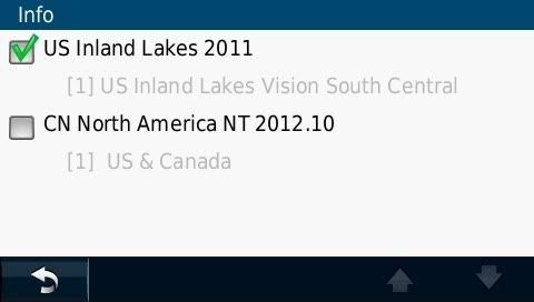
I decided to run the risk and purchase the Nuvi 1450LM. I also purchased and downloaded the Inland Lakes Vision South Central region from Garmin. I got the Nuvi for $162.99, and extra suction cup mount for $9.77 and downloaded the mapset for $107ish after taxes (NOTE: if you check your e-mail immediately following GArmin account creation and BEFORE you purchase anything from Garmin on their website, you may get a 10% discount code. I had already purchased the Inland Lakes mapset when I got the e-mail offering 10% off anything from the website) Now I'm in it for $280ish.....

I installed the mapset and was surprised when I scrolled to a lake and nothing looked any different. I sent an e-mail to Garmin and asked for their help. They responded with the following

Thank you for contacting Garmin International.

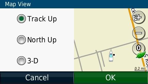
Unfortunately, your unit does not have a boating mode because it is not a unit designed for marine use. However, the mapping can still show up on the unit, but with limitations. What this means is that Inland Lakes will provide access to basic shoreline and depth detail and limited points of interest. When viewing this mapping on your device, please ensure that you have disabled your City Navigator mapping and changed your Map View from the default 3D view to either Track Up or North Up
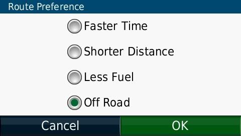
You will also want to change your Route Preference/Calculation Mode to Off Road to ensure that you can route to a location properly.

So I have to disable the City Nav (limits the Points of Interest, can't search for food or gas etc.)
Image
Set the GPS to offroad, so it won't route me to a street
Image
Turn off the 3-D view (I don't like it anyway)
Image
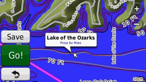
After all that what you get is the following

Image


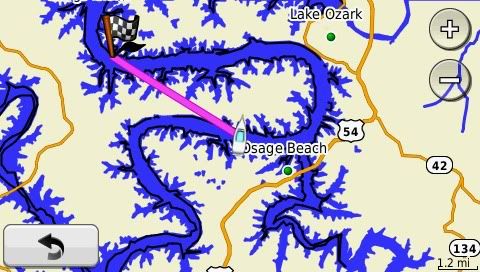
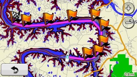
I set a destination at LOTO and set my location to a few mile markers away, notice the GPS wants you to go in a straight line, not a good idea in a boat......

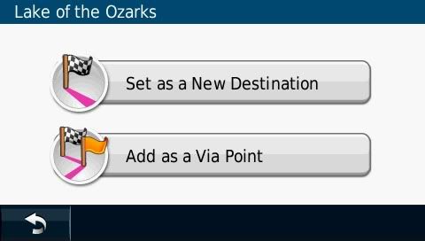
Fix it by adding "Via" points from the destination backwards
Image
Image
Image
Image
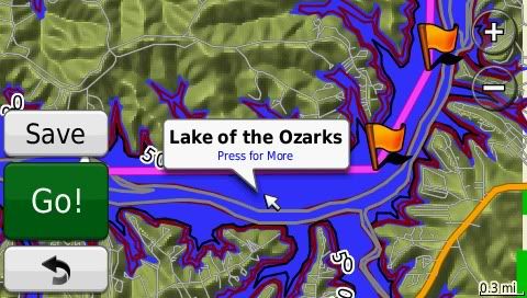
Be careful that you are at a close enough zoom in level to make sure that you are not cutting a corner!! Again not a good idea in a boat...


At the end of all that you get the following
Image
Image
Image
Image

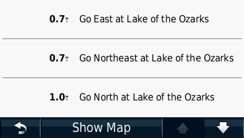
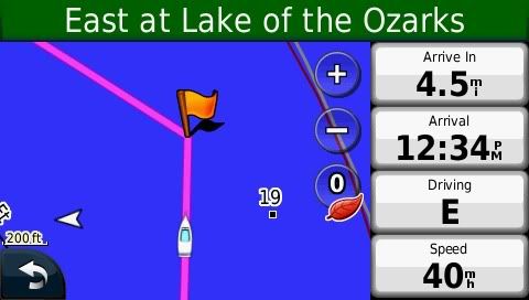
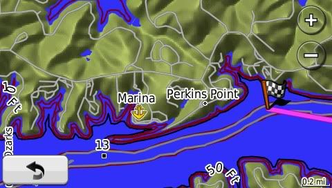
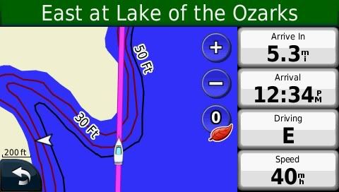
A 30 mile trip on LOTO took about 15 minutes to program and save as a route for future use. I mainly wanted advance warning of shallow water and maybe some situational awareness of where the nearest marina is, so this setup will work for me for now. I can add points of interest to the map as i find them, so that will be helpful later as well. If anyone else has questions, let me know.

_________________
Tanker Toad
NKAWTG..N!!
2008 H220 SS
2008 Chevy Silverado 4x4
2010 Tahoe LT 4x4
Image


Top
 Profile  
 
PostPosted: Thu Jul 14, 2011 4:08 pm 
Offline
Villiage Idiot

Joined: Sat Dec 15, 2007 8:28 pm
Posts: 1405
Location: Kansas City
That's good to know. Maybe I'll do the same on the software with my Nuvi 1350 when I get tired of the small screen on the Black and White eTrex.

Anyone out there know if the same map-set would work with both the eTrex Legend and Nuvi?

_________________
Walt B
"Debt-Charged"
Black '07 H210SS
6.2L Bravo One turning a 21P HIFive
Wakeboard Tower with Perfect Pass Stargazer version
Missouri River; Kansas City, Mo.


Top
 Profile  
 
PostPosted: Thu Jul 14, 2011 4:34 pm 
Offline
email admin your custom rank

Joined: Wed Jun 01, 2011 10:21 am
Posts: 5667
Location: Austin, TX
For $50 more you could have got a Garmin GPSMAP 421........

_________________
1981 Columbia 8.7
2015 Yamaha FZR - 87mph - sold
2006 Yamaha GP1300R - sold
2003 Chaparral 215 SSI - sold
2009 Stingray 195CS - sold
2000 Four Winns H180 - sold
1976 O'day Daysailer II - sold

Rick's Four Winns H180 Mods/Upgrade Thread


Top
 Profile  
 
PostPosted: Thu Jul 14, 2011 7:44 pm 
Offline
email admin your custom rank

Joined: Sun Nov 21, 2010 8:03 am
Posts: 2238
Location: Winthrop, Ma.
FOR GIVE ME!! I do agree with Garmin, it is not a marine unit. First off, it is not rated water proof to 3 meters for 30min, don't get it wet! The Nuvi is a great unit, I have one in my car. Also it is not sun light viewable, no anchor alarm, no real way piont & route planning, no tide table and more....................

Use it for your car & pick up Garmins 4 or 5" marine unit.


Top
 Profile  
 
PostPosted: Thu Jul 14, 2011 8:17 pm 
Offline
Villiage Idiot

Joined: Sat Dec 15, 2007 8:28 pm
Posts: 1405
Location: Kansas City
I did just look up the same for my application.... According to Garmin's website, My eTrex Legend AND Nuvi1350 can use the same lake-map software... and it's $100. Not too shabby. Maybe a x-mas present to me, or something.

Thanks for the thread, and info Todd!


Edit...
.... and another thanks. I just did the same using my Mapsource Topo software that came with my eTrex. This works, and has the "Basic" information I already use in my on-boat hand-held. This will be better by having the bigger, color display of my Nuvi, with the topo/relative depth and waypoints (fishing spots) already programmed in.

_________________
Walt B
"Debt-Charged"
Black '07 H210SS
6.2L Bravo One turning a 21P HIFive
Wakeboard Tower with Perfect Pass Stargazer version
Missouri River; Kansas City, Mo.


Top
 Profile  
 
PostPosted: Fri Jul 15, 2011 2:38 pm 
Offline
Sting Ray

Joined: Fri Sep 17, 2010 12:58 pm
Posts: 71
Paul I. wrote:
FOR GIVE ME!! I do agree with Garmin, it is not a marine unit. First off, it is not rated water proof to 3 meters for 30min, don't get it wet! The Nuvi is a great unit, I have one in my car. Also it is not sun light viewable, no anchor alarm, no real way piont & route planning, no tide table and more....................

Use it for your car & pick up Garmins 4 or 5" marine unit.


You are forgiven, my son.....

I knew the Garmin was not a "MARINE" unit,
I also know that I don't anchor overnight and don't need no stinkin' anchor alarm,
If my Nuvi gets anything other than a slight spray on it, I probably have bigger problems, like sinking or capsizing and don't really care if it withstands the 3 meter/30 minute water test parameters,
Since I am only on inland lakes, I can usually see land all around me, the VIA points can help guide my way and keep me out of shallow water (kind like WAYPOINTS and ROUTE PLANNING...),
This purchase was more for situational awareness on lakes that I have not been to previously
Tide tables are NA on inland lakes
My windows are tinted so I don't think that sunlight is going to be much of a factor, unless it is behind me, then I can usually block the sun with my rather large head....... It's got its own weather system, kinda like an orange on a toothpick......


Thanks for the input though

_________________
Tanker Toad
NKAWTG..N!!
2008 H220 SS
2008 Chevy Silverado 4x4
2010 Tahoe LT 4x4
Image


Top
 Profile  
 
PostPosted: Fri Jul 15, 2011 3:18 pm 
Offline
230 Mike
User avatar

Joined: Mon May 15, 2006 7:59 pm
Posts: 5141
Location: Kansas City, Table Rock Lake
My eTrex Vista C works well on most of the same lakes, with just City Select North America. It even has an anchor alarm, which I also have no use for. No depth or hazard data but I haven't cared.

_________________
Image

Mike
2005 Four Winns 230/240
VP 5.7GXi/DP
1998 F-150 XLT
Boat Pic


Top
 Profile  
 
PostPosted: Fri Jul 15, 2011 3:51 pm 
Offline
email admin your custom rank

Joined: Sun Nov 21, 2010 8:03 am
Posts: 2238
Location: Winthrop, Ma.
Tanker Toad wrote:
Paul I. wrote:
FOR GIVE ME!! I do agree with Garmin, it is not a marine unit. First off, it is not rated water proof to 3 meters for 30min, don't get it wet! The Nuvi is a great unit, I have one in my car. Also it is not sun light viewable, no anchor alarm, no real way piont & route planning, no tide table and more....................

Use it for your car & pick up Garmins 4 or 5" marine unit.


You are forgiven, my son.....

I knew the Garmin was not a "MARINE" unit,
I also know that I don't anchor overnight and don't need no stinkin' anchor alarm,
If my Nuvi gets anything other than a slight spray on it, I probably have bigger problems, like sinking or capsizing and don't really care if it withstands the 3 meter/30 minute water test parameters,
Since I am only on inland lakes, I can usually see land all around me, the VIA points can help guide my way and keep me out of shallow water (kind like WAYPOINTS and ROUTE PLANNING...),
This purchase was more for situational awareness on lakes that I have not been to previously
Tide tables are NA on inland lakes
My windows are tinted so I don't think that sunlight is going to be much of a factor, unless it is behind me, then I can usually block the sun with my rather large head....... It's got its own weather system, kinda like an orange on a toothpick......


Thanks for the input though


I use the anchor alarm most of the time. There been times that where having lunch and not realize that it’s slipping.
BUT, if that makes you happy thats great, I just wanted to piont things out to you.


Top
 Profile  
 
PostPosted: Fri Jul 15, 2011 6:33 pm 
Offline
Villiage Idiot

Joined: Sat Dec 15, 2007 8:28 pm
Posts: 1405
Location: Kansas City
Paul I. - As always, we do appreciate your perspectives and experiences relating to the matter. If I suggested or implied otherwise, I am sorry.

Todd/Mike,
I'm going to try my Nuvi 1350 this weekend using the MapSource TOPO software used from my eTrex Legend. I will compare, and post findings. Since I already have and use both, I may as well see how the Nuvi does on the water! I could nearly load ALL of the USA maps onto it. I also have a multi-use RAM mount in the boat presently used for the eTrex that should be just big enough for the Nuvi.

_________________
Walt B
"Debt-Charged"
Black '07 H210SS
6.2L Bravo One turning a 21P HIFive
Wakeboard Tower with Perfect Pass Stargazer version
Missouri River; Kansas City, Mo.


Top
 Profile  
 
PostPosted: Mon Jul 18, 2011 9:57 am 
Offline
email admin your custom rank

Joined: Sun Nov 21, 2010 8:03 am
Posts: 2238
Location: Winthrop, Ma.
Walt wrote:
Paul I. - As always, we do appreciate your perspectives and experiences relating to the matter. If I suggested or implied otherwise, I am sorry.

Todd/Mike,
I'm going to try my Nuvi 1350 this weekend using the MapSource TOPO software used from my eTrex Legend. I will compare, and post findings. Since I already have and use both, I may as well see how the Nuvi does on the water! I could nearly load ALL of the USA maps onto it. I also have a multi-use RAM mount in the boat presently used for the eTrex that should be just big enough for the Nuvi.


Don't feel sorry!! I Never even took it that way!! One thing I need to reminber, that most of the boaters here are lake boaters. I am a ocean boater and have a differant perspective on things. Case in piont is this topic, being on the ocean, we would never use a GPS that is not marine rated.


Top
 Profile  
 
PostPosted: Mon Jul 18, 2011 5:35 pm 
Offline
Villiage Idiot

Joined: Sat Dec 15, 2007 8:28 pm
Posts: 1405
Location: Kansas City
As stated above, my input comparing B/W Hand-held eTrex Legend to Nuvi 1350, both w/ Standard Mapsource Topo software....
Negatives using the Nuvi- the Depth gradients didn't seem to be as well/as clearly marked;
A little cumbersome going from "Road-use" to "Water-Use";
The suction cup mount didn't seem to attractive in the boat... will try my other RAM mount next trip.

Positives- Much bigger screen, with bigger buttons, and touch screen;
Color seems more informative than B/W;
QWERTY Keyboard layout, vice arrow/clicker;
Accusition time seems quicker

They seem a little obvious in hind-sight, but hope that helps someone considering the idea.

_________________
Walt B
"Debt-Charged"
Black '07 H210SS
6.2L Bravo One turning a 21P HIFive
Wakeboard Tower with Perfect Pass Stargazer version
Missouri River; Kansas City, Mo.


Top
 Profile  
 
PostPosted: Tue Jul 19, 2011 7:44 am 
Offline
Sting Ray

Joined: Fri Sep 17, 2010 12:58 pm
Posts: 71
Walt,

Do you think you get more depth info with the Trex, ie, depth in increments of 5' vs 20' or is it dependent on the map information that Garmin has programmed?

Again, I don't need to follow every inch of contour on the bottom of the lake, just want to know when shallow areas are nearby.

Much thanks for the comparison!

Toad

_________________
Tanker Toad
NKAWTG..N!!
2008 H220 SS
2008 Chevy Silverado 4x4
2010 Tahoe LT 4x4
Image


Top
 Profile  
 
PostPosted: Tue Jul 19, 2011 5:17 pm 
Offline
Villiage Idiot

Joined: Sat Dec 15, 2007 8:28 pm
Posts: 1405
Location: Kansas City
The eTrex seems to be 5' or 10' increments, while the nuvi is 20'. Not much variation on a lake that's only about 40' at the deepest.

FYI, I loaded the same mapsets at the same time, using the same settings. The nuvi was a quicker load. When I used them side-by-side "Most" of the shallow areas are marked on Smithville.... I did notice one on the eTrex, not shown on the nuvi, but saw a few others.... not sure why the difference.

_________________
Walt B
"Debt-Charged"
Black '07 H210SS
6.2L Bravo One turning a 21P HIFive
Wakeboard Tower with Perfect Pass Stargazer version
Missouri River; Kansas City, Mo.


Top
 Profile  
 
PostPosted: Thu Jul 21, 2011 11:55 pm 
Offline
Sting Ray

Joined: Fri Sep 17, 2010 12:58 pm
Posts: 71
Going to LOTO in the morning. I am going to give the Nuvi a try and will post the results when I get back next week. Safe boating to you all!!

_________________
Tanker Toad
NKAWTG..N!!
2008 H220 SS
2008 Chevy Silverado 4x4
2010 Tahoe LT 4x4
Image


Top
 Profile  
 
PostPosted: Mon Nov 14, 2011 8:46 am 
Offline
Goldfish

Joined: Tue Aug 30, 2011 10:04 am
Posts: 39
Location: Upstate NY
Tanker Toad wrote:
Going to LOTO in the morning. I am going to give the Nuvi a try and will post the results when I get back next week. Safe boating to you all!!


Where are the results???

_________________
2008 Horizon 180 Volvo Penta 3.0
Image


Top
 Profile  
 
Display posts from previous:  Sort by  
Post new topic Reply to topic  [ 18 posts ]  Go to page 1, 2  Next

All times are UTC - 6 hours [ DST ]


Who is online

Users browsing this forum: No registered users and 20 guests


You cannot post new topics in this forum
You cannot reply to topics in this forum
You cannot edit your posts in this forum
You cannot delete your posts in this forum

Search for:
Jump to:  
Powered by phpBB® Forum Software © phpBB Group