I bought the Lowrance HDS8 with Structure Scan and the Insight mapping option a couple years ago. I like it a lot. I can add radar (if I had an arch), fuel flow and various other temp, quantity, and engine sensors as desired. It can be tied into an AIS unit and the VHF radio also. I have used it to keep track of distance traveled by day, by trip, and by the boating season.
The Gen 2 units came out shortly after I bought this unit, and it would be nice to have a touch screen. The process to add text such as waypoints is a little slow on the one I got.
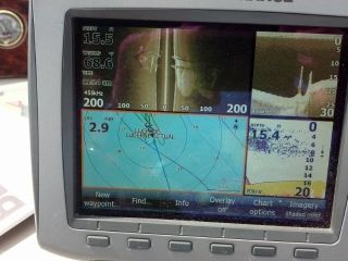
This photo is what we saw with the Lowrance Structure Scan of a shipwreck in the Lake Superior Apostle Islands area. This shipwreck is the Lucerne, a 195 foot wooden sailing iron ore freighter that was launched in 1873, and sank in a November 1886 storm. We dove on this site 3 1/2 years ago and saw an anchor winch gear with a casting date of 1851, a decade before the U.S. Civil War. Cold fresh water has preserved this wreck surprisingly well.